chicagopcclcar Posted September 29, 2012 Report Share Posted September 29, 2012 Bruce Moffat, renowned 'L' historian and an all-around nice guy, gave me a copy of a photo he came across and I said to myself, let the list get in on the fun of identifying the location. If you been following my series on the construction and location of Chicago's historic 'L' lines, you should be a step ahead of the crowd. So lets it started....there are no clues from me. Just tell us where is it and why do you think so. David Harrison Quote Link to comment Share on other sites More sharing options...
eyetube21 Posted September 29, 2012 Report Share Posted September 29, 2012 Bruce Moffat, renowned 'L' historian and an all-around nice guy, gave me a copy of a photo he came across and I said to myself, let the list get in on the fun of identifying the location. If you been following my series on the construction and location of Chicago's historic 'L' lines, you should be a step ahead of the crowd. So lets it started....there are no clues from me. Just tell us where is it and why do you think so. David Harrison Is it 61st Street station on the Jackson Park "L". Quote Link to comment Share on other sites More sharing options...
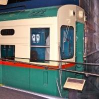
chicagopcclcar Posted September 29, 2012 Author Report Share Posted September 29, 2012 Is it 61st Street station on the Jackson Park "L". I like your geographical reference. 61st St. was on the 1893 extension to Jackson Park, true. But the yard just to the east was built at the same time and a corner of it should show in this photo. Three to four years later, the shops' building was put up north of the yard, and that would have to be in the picture too. In 1898 steam operations on the South Side elevated ceased. Another thing to saying this is not 61st is that when the 'L' was built there were no structures west of the 'L' south of 51st St. and the buildings in the background are evidence against this being 61st St. David Harrison Quote Link to comment Share on other sites More sharing options...
eyetube21 Posted September 29, 2012 Report Share Posted September 29, 2012 I like your geographical reference. 61st St. was on the 1893 extension to Jackson Park, true. But the yard just to the east was built at the same time and a corner of it should show in this photo. Three to four years later, the shops' building was put up north of the yard, and that would have to be in the picture too. In 1898 steam operations on the South Side elevated ceased. Another thing to saying this is not 61st is that when the 'L' was built there were no structures west of the 'L' south of 51st St. and the buildings in the background are evidence against this being 61st St. David Harrison Oh, I was close. Thanks, David. I like historical photos of CTA buses and trains. Maybe next time, I'll get it right. haha.. Quote Link to comment Share on other sites More sharing options...
chicagopcclcar Posted September 29, 2012 Author Report Share Posted September 29, 2012 Oh, I was close. Thanks, David. I like historical photos of CTA buses and trains. Maybe next time, I'll get it right. haha.. Stay tuned anyway....I'll have to get a chance to check the Sandborn Maps for the presence of property built up on Indiana Ave. And if that is an expansion joint in the 'L' girder just north of the station, that might also be a clue. Expansion joints don't get changed, despite 100 plus years. The 4700 south block of Prairie Ave. would have had a frame structure at 4706 which would be blocked in this view. So 47th St. is the most likely location. David H. Quote Link to comment Share on other sites More sharing options...
eyetube21 Posted September 29, 2012 Report Share Posted September 29, 2012 Stay tuned anyway....I'll have to get a chance to check the Sandborn Maps for the presence of property built up on Indiana Ave. And if that is an expansion joint in the 'L' girder just north of the station, that might also be a clue. Expansion joints don't get changed, despite 100 plus years. The 4700 south block of Prairie Ave. would have had a frame structure at 4706 which would be blocked in this view. So 47th St. is the most likely location. David H. My pleasure. I'm looking forward to see it soon. I also familiar at 47th Street and Prairie Avenue. I go to this area a lot. That's where I catch the Green Line train at 47th Street station. Quote Link to comment Share on other sites More sharing options...
Busjack Posted September 30, 2012 Report Share Posted September 30, 2012 My pleasure. I'm looking forward to see it soon. I also familiar at 47th Street and Prairie Avenue. I go to this area a lot. That's where I catch the Green Line train at 47th Street station. Ray's Music Exchange isn't in the picture. Anyway, from Chicago-l.org, it will be hard to make a definite comparison, because the station was rebuilt in 1982 with a new station house, and thus, to a lesser extent, in 1996 (when the elevators were added). The picture corresponds to the description of the original station house, but all of them on that stretch were said to be the same. Quote Link to comment Share on other sites More sharing options...
chicagopcclcar Posted September 30, 2012 Author Report Share Posted September 30, 2012 Ray's Music Exchange isn't in the picture. Anyway, from Chicago-l.org, it will be hard to make a definite comparison, because the station was rebuilt in 1982 with a new station house, and thus, to a lesser extent, in 1996 (when the elevators were added). The picture corresponds to the description of the original station house, but all of them on that stretch were said to be the same. Wrong, the entire stations and platforms were not all the same on that stretch. 61st, 47th, and 43rd had the station house north of the cross street and the platforms extended to the south. 51st had the station house on the south side of the cross street and the platforms extended to the north. 58th St. had a middle platform and a station house north of the cross street. It's not the original 'L' north of 39th St. before it was third-tracked because the uprights are of a different style. And its not Indiana Ave/40th St. because there are no railroad tracks. I can make a definite comparison despite the rebuilds....I have already charted the existance of every building that was present when the line was extended in 1893 using Sanborn Maps. But I charted Calumet and Prairie Avenues only. I did not chart Indiana Ave. because it wasn't really viewable from the 'L' train. I use the charts to point out certain buildings on charters. The buildings in the background might be on Indiana Ave., as no charted buildings were on Prairie Ave on that side. What I know so far...its probably not 43rd St because there would be some buildings in the 4300 block on the odd side of Prairie Ave.. There are none in the photo. It's not 61st St. becaues of the previously mentioned items. That leaves 47th St. When I check the Sanborn Maps, I will see if there were buildings on Indiana Ave. that match the photograph. The icing on the cake will be if there is an expansion joint in the steel girders when I make an inspection trip to 47th St. this week. They never get changed, and anyway, its outside any station work. David Harrison Quote Link to comment Share on other sites More sharing options...
chicagopcclcar Posted September 30, 2012 Author Report Share Posted September 30, 2012 Here's another one for ya....what station was planned and provided for in the original alley 'L' steel work but was never built? Stations built: Congress, 12th St., 18th St., 22nd St., 26th St., 29th St., 31st St., 33rd St., 35th St. 39th St., Indiana, 43rd St., 47th St., 51st St. Garfield Blvd., 58th St., 61st St., South Park, Cottage Grove, University, Madison, Stony Island, Jackson Park. This is the only clue I'll give....what's missing. David Harrison Quote Link to comment Share on other sites More sharing options...
Busjack Posted September 30, 2012 Report Share Posted September 30, 2012 Wrong, the entire stations and platforms were not all the same on that stretch.... I was relying on the descriptions and pictures of the station houses only. The best I could tell from chicago-l.org is that most of the platforms had some change between 1892 (obviously this picture was taken before the line was converted to MU) and 1992. Quote Link to comment Share on other sites More sharing options...
eyetube21 Posted September 30, 2012 Report Share Posted September 30, 2012 Here's another one for ya....what station was planned and provided for in the original alley 'L' steel work but was never built? Stations built: Congress, 12th St., 18th St., 22nd St., 26th St., 29th St., 31st St., 33rd St., 35th St. 39th St., Indiana, 43rd St., 47th St., 51st St. Garfield Blvd., 58th St., 61st St., South Park, Cottage Grove, University, Madison, Stony Island, Jackson Park. This is the only clue I'll give....what's missing. David Harrison Is it Congress Street terminal in downtown? Quote Link to comment Share on other sites More sharing options...
chicagopcclcar Posted September 30, 2012 Author Report Share Posted September 30, 2012 Is it State Street station and 59th Street on the Englewood Branch? The Alley 'L' is only the original Chicago elevated from Congress to 39th in 1892 and extended to Jackson Park in 1893 and cut back to Stony Island in 1893. It does not include any other branch on the South Side. FYI...stations on the Englewood branch were: State, Wentworth, Princeton, 63rd St. Parnell, Halsted, Center, Loomis Blvd. David H. Quote Link to comment Share on other sites More sharing options...
eyetube21 Posted September 30, 2012 Report Share Posted September 30, 2012 The Alley 'L' is only the original Chicago elevated from Congress to 39th in 1892 and extended to Jackson Park in 1893 and cut back to Stony Island in 1893. It does not include any other branch on the South Side. FYI...stations on the Englewood branch were: State, Wentworth, Princeton, 63rd St. Parnell, Halsted, Center, Loomis Blvd. David H. Oh, I see. Yeah, the Englewood branch was built in 1905, after the South Side Elevated begins. Quote Link to comment Share on other sites More sharing options...
chicagopcclcar Posted September 30, 2012 Author Report Share Posted September 30, 2012 I was relying on the descriptions and pictures of the station houses only. The best I could tell from chicago-l.org is that most of the platforms had some change between 1892 (obviously this picture was taken before the line was converted to MU) and 1992. Yes, there were changes, but most were just platform extensions. Note that in this picture that is a five car train berthing at what we would call a four-car platform. They did this how.....by not using the end doors. This is the way the eight car trains stopped at Ravenswood stations way back in the 1940s when the Ravenswood went through the subway. That route was called "Englewood/Ravenswood/Albany Park via Subway" on the front signboards. Nowadays, the Ravenswood stations had to be remade and extended to accomodate today's eight car trains. But getting back to changes, when the third track was added to the South Side, 39th, 22nd changed platform directions entirely and 35th had one platform going one way and the other platform going the other way. David H. Quote Link to comment Share on other sites More sharing options...
chicagopcclcar Posted September 30, 2012 Author Report Share Posted September 30, 2012 Is it Congress Street terminal in downtown? Congress is first on my list of clues. David Quote Link to comment Share on other sites More sharing options...
eyetube21 Posted September 30, 2012 Report Share Posted September 30, 2012 Congress is first on my list of clues. David That was the first clue that I was thinking of. But, I thought it was State Street station at first. I know there are two Congress Street stations. One was Congress Street on Wabash Avenue and the other one was the terminal along the alley. I read the Congress Street terminal and it was built in 1902. Quote Link to comment Share on other sites More sharing options...
Busjack Posted September 30, 2012 Report Share Posted September 30, 2012 Is it Congress Street terminal in downtown? One would think so, as it was at Congress and the alley between State and Wabash. As chicago-l.org points out, that was the original terminal of the South Side Elevated, until such time as the Harrison curve was constructed to connect it with the later constructed Loop L. Krambles' book pointed out that the various stub terminals (such as across from the Merchandise Mart and on Wells north of Van Buren, where the CA&E terminal was), lost their usefulness shortly after WWII and the through routing of trains through the subway, and were quickly abandoned by CTA. CTA gave us this one in 1949, but the North Shore Line used it until 1963 as a baggage terminal. Update: If you meant a separate station at Congress-Wabash leading to the loop, well, there was a station there, according to Chicago-l.org. Since the question is what station was planned but never built, one would have to scratch one's head about where there is a cross street where it wasn't worth it to build a station, even though there were ones every 1/2 mile, or even less. I would have guessed 26th or 31st, but chicago-l.org indicates that there were stations there at some time, and also at 29th and 33rd. So, I pass. Quote Link to comment Share on other sites More sharing options...
eyetube21 Posted September 30, 2012 Report Share Posted September 30, 2012 One would think so, as it was at Congress and the alley between State and Wabash. As chicago-l.org points out, that was the original terminal of the South Side Elevated, until such time as the Harrison curve was constructed to connect it with the later constructed Loop L. Krambles' book pointed out that the various stub terminals (such as across from the Merchandise Mart and on Wells north of Van Buren, where the CA&E terminal was), lost their usefulness shortly after WWII and the through routing of trains through the subway, and were quickly abandoned by CTA. CTA gave us this one in 1949, but the North Shore Line used it until 1963 as a baggage terminal. Update: If you meant a separate station at Congress-Wabash leading to the loop, well, there was a station there, according to Chicago-l.org. Since the question is what station was planned but never built, one would have to scratch one's head about where there is a cross street where it wasn't worth it to build a station, even though there were ones every 1/2 mile, or even less. I would have guessed 26th or 31st, but chicago-l.org indicates that there were stations there at some time, and also at 29th and 33rd. So, I pass. Yeah, according to Chicago-L.org that Congress Terminal was renamed "Old Congress" station. This station was served by the Englewood trains that time. It's very interesting. Quote Link to comment Share on other sites More sharing options...
chicagopcclcar Posted September 30, 2012 Author Report Share Posted September 30, 2012 The location were the station was provided for is 24th St. Columns at non-station locations are normally are beneath the track centers. At station locations notice that the upright columns are located on the outside of the outer track girder. That is so that the platforms can be directly attached. But since this station was never built, it was never raised to provide space for the mezanine area and clearance under the structure like 18th through 39th. But the new third track on the left followed the same format. The tall footings are from the Green line rehab, they're not original. Thanks for participating. Another note: Many of you know that the alley 'L' was actually built NEXT TO the alley, but the third track was allowed over the alley by the city if the 'L' paved the entire three track space and allowed public access. This was one of those rare exceptions...there was no alley next to the 'L', so the entire right of way, three tracks wide, is private land, owned by the 'L'. Little details, LOL. David H. Quote Link to comment Share on other sites More sharing options...
Busjack Posted September 30, 2012 Report Share Posted September 30, 2012 The location were the station was provided for is 24th St. ... With a station every two blocks, I can now see why they had to build an express track. I suppose that the L might have been faster than the streetcars on State or Cottage Grove, but not by much. Of course, there is now the similar talk of local-express service on the north side, with a station there every three blocks or less north of Wilson. Quote Link to comment Share on other sites More sharing options...
chicagopcclcar Posted September 30, 2012 Author Report Share Posted September 30, 2012 With a station every two blocks, I can now see why they had to build an express track. I suppose that the L might have been faster than the streetcars on State or Cottage Grove, but not by much. Of course, there is now the similar talk of local-express service on the north side, with a station there every three blocks or less north of Wilson. Remember though, when the Alley 'L' was built, its competition was the cable car, not the streetcar. Whereas most people think of San Francisco when the subject of cable car is mentioned, Chicago had the largest cable car system and the two south side lines were the longest; State St. cable went all the way to 63rd St. and the Cottage Grove cable went out to 71st St. The term Loop for the downtown area comes from the cable cars and not from the elevated. When the streecars came onto the scene, the 'L' and the streetcar were in competition, so yes, the closely spaced stations were necessary. People never ran to the corner to catch a streetcar like you see some today dashing against the red light to catch a CTA bus. The streetcar company operated on the premise, "Always another in sight." How that Red/Purple gets sorted out in the future will be real interesting. A lot will hinge on the outcome of November's elections. For transit there is only one choice. David H. Quote Link to comment Share on other sites More sharing options...
chicagopcclcar Posted October 3, 2012 Author Report Share Posted October 3, 2012 Is it 61st Street station on the Jackson Park "L". After a neighorhood recon mission, 61st St. is back in the running. The yard structure is far enough back so that it would not have shown up in the photo. I've gotta wait until I can check the appropriate Sanborn Maps to identify those buildings in the background. DH Quote Link to comment Share on other sites More sharing options...
SE CTA Fan Posted October 3, 2012 Report Share Posted October 3, 2012 David - Long time lurker here, first time posting in a long, long time. I can't add any information on where this station might be located, but I do have a question on one of your earlier posts in this thread. You mentioned that there was an expansion joint located in the structure north of the station. I couldn't find this. Can you describe what this looked like? As a side note, I am attempting to gather information on making a more prototypically accurate model of the L structure and haven't seen these (the expansion joints) before (or knew what they were called). While there is a lot of information on build dates, cars and other equipment, there isn't a lot of data on the actual structure that I've been able to find (aside from viewing it in person). Thanks in advance. Terry G http://ctalayout.blogspot.com/ Quote Link to comment Share on other sites More sharing options...
chicagopcclcar Posted October 3, 2012 Author Report Share Posted October 3, 2012 David - Long time lurker here, first time posting in a long, long time. I can't add any information on where this station might be located, but I do have a question on one of your earlier posts in this thread. You mentioned that there was an expansion joint located in the structure north of the station. I couldn't find this. Can you describe what this looked like? As a side note, I am attempting to gather information on making a more prototypically accurate model of the L structure and haven't seen these (the expansion joints) before (or knew what they were called). While there is a lot of information on build dates, cars and other equipment, there isn't a lot of data on the actual structure that I've been able to find (aside from viewing it in person). Thanks in advance. Terry G http://ctalayout.blogspot.com/ Hi Terry,welcome to the group. Not too many people are interested in how the 'L' structure is put together so that is why material is hard to come by. Here's a short, short lesson in engineering. A simple railroad bridge like the through girder bridges across streets seen in Chicago...one end is bolted down to the pier or wall, the other end sits on a roller which allows the bridge to expand and contract. The 'L' is a series of bridges, one after another, for miles and miles. Every so often, like maybe a half block, the girders under the track have to alow for this movement, so there they will not be attached, but sit in a holder of some kind. The joints under the Northwestern and some downtown ae easy to see. What I thought was an expansion joint in the picture isn't an expansion joint. The South Side put a narrow piece of something in each open space between the girders where the spread top columns are located. Over time, they've disappeared. I don't know if the South Side even has expansion joints. I'll have to go look. If you do, remember the structure north of 39th is different then the structure south and east of 39th. DH Quote Link to comment Share on other sites More sharing options...
SE CTA Fan Posted October 3, 2012 Report Share Posted October 3, 2012 David - Thanks for the explanation. I think I was over-thinking what those would be ... maybe I was looking for something larger. I thought that they would be those X-shaped stiffening sections found every fourth bent on the northside or Ravenswood structure. I don't know what those are actually called. But, I've included them on my O scale model (at least I've tried to make it every fouth bent) and have found that they really do work. Those sections really help "stiffen" things up, so to speak. But, looking at the picture again, I realized that the section of structure shown in the picture is missing those X-shaped sections, so that looks to be used on the northside only (I could be very wrong, just my guess). And yes, you are correct ... not a lot of documentation to be had on the actual structure itself. So, I've made do with my casual observations. My structure is pretty basic, but was quick to build. Someday I hope to have something better/more prototypically accurate. Thanks again, Terry G Quote Link to comment Share on other sites More sharing options...

Recommended Posts
Join the conversation
You can post now and register later. If you have an account, sign in now to post with your account.